Friday, January 12, 2018

China launches latest Beidou-3M satellite duo

A new pair of navigation satellites were successfully launched by China on Thursday, using a Long March-3B/YZ-1. The launch of the Beidou-3M pair took place at around 23:18 UTC from the LC2 Launch Complex of the Xichang Satellite Launch Center, Sichuan province. It took over four hours to complete the mission.The launch was previously scheduled for 2017. However, this was delayed due to a partial launch failure with a previous launch of this rocket during the Zhongxing-9A (ChinaSat-9A) mission, which resulted in the satellite being lofted to a lower than planned orbit. It is expected that the Beidou-3MEO3 (Beidou-26) and Beidou-3MEO4 (Beidou-27) satellites will be onboard, but a TV news report following last November’s BDS launch – featuring the satellite production facility in Shanghai – referred that the two satellites about to be shipped were marked as “M7 & M8”. So, we will have to wait what designation is given to the satellites when in orbit.

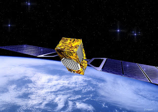


The MEO satellites are the Medium Earth Orbit component of the 3rd phase of the Chinese Beidou (Compass) satellite navigation system. The satellites are part of a fleet that will expand the system to a global navigation coverage.


The satellites are using a new bus that features a phased array antenna for navigation signals and a laser retroreflector, with a launch mass 1,014 kg. Spacecraft dimensions are noted to be 2.25 by 1.0 by 1.22 meters. Usually, the satellites reside in a 21,500 – 21,400 km nominal orbit at 55.5 degrees.

The Beidou Phase III system includes the migration of its civil Beidou 1 or B1 signal from 1561.098 MHz to a frequency centered at 1575.42 MHz – the same as the GPS L1 and Galileo E1 civil signals – and its transformation from a quadrature phase shift keying (QPSK) modulation to a multiplexed binary offset carrier (MBOC) modulation similar to the future GPS L1C and Galileo’s E1.

The Phase II B1 open service signal uses QPSK modulation with 4.092 megahertz bandwidth centered at 1561.098 MHz.

The current Beidou constellation spacecraft are transmitting open and authorized signals at B2 (1207.14 MHz) and an authorized service at B3 (1268.52 MHz).

Real-time, stand-alone Beidou horizontal positioning accuracy was classed as better than 6 meters (95 percent) and with a vertical accuracy better than 10 meters (95 percent).

The Compass Navigation Satellite System (CNSS) is China’s satellite navigation system, approved by the Chinese government in 2004, capable of providing continuous, real-time passive 3D geo-spatial positioning and speed measurement.

The Chinese navigation system is being developed and deployed in three phases. Phase 1 (starting in 2003), consisted of an experimental regional navigation system, BeiDou-1, which provided active navigation service.

Phase 2 (started in 2012), consisted of a reduced satellite constellation and provides open service over China. This phase aimed at deploying a system with passive positioning and timing capability over a regional area.

Phase 3 aims for full operational capability by 2020 with a constellation of 27 MEOs plus 5 GEOs and the existing 3 IGSOs satellites of the regional system. CNSS would provide global navigation services, similarly to the GPS, GLONASS or Galileo systems.

CNSS is expected to support two different kinds of general services: RDSS and RNSS. In the Radio Determination Satellite Service (RDSS), the user position is computed by a ground station using the round trip time of signals exchanged via GEO satellite. The RDSS long-term feature further includes short message communication (guaranteeing backward compatibility with Beidou-1), large volume message communication, information connection, and extended coverage.

The Radio Navigation Satellite Service (RNSS) is very similar to that provided by GPS and Galileo and is designed to achieve similar performances.

The long-term goal is to develop a global navigation satellite network similar to the GPS and GLONASS by 2020 eventually consisting a constellation of 35 vehicles, including 27 MEO (21,500 km orbits) satellites, three IGSO satellites (inclined at 55 degrees) and five GSO satellites.

The system will be dual-use, based on a civilian service that will provide an accuracy of 10 meters in the user position, 0.2 m/s on the user velocity and 50 nanoseconds in time accuracy; and the military and authorized user’s service, providing higher accuracies. The first phase of the project will involve coverage of the Chinese territory. However, the future Compass constellation will cover the entire globe.

This mission is also the second flight of the Long March-3B/YZ-1 (Chang Zheng-3B/YZ-1) version of the Long March-3B. The launcher was developed from the Chang Zheng-3A.

Wednesday, January 10, 2018

China opens 2018 with Long March 2D flight of two SuperView-1 satellites

China’s Long March 2D booster launched into space on Tuesday, January 9, at 11:24 a.m. Beijing time (10:24 p.m. EST and 03:24 GMT on Jan. 8) sending a duo of SuperView-1 satellites into orbit. The mission, which opens Beijing’s busy 2018 launch manifest, lifted off from the Taiyuan Satellite Launch Center (TSLC) located in China’s Shanxi Province. Following a usual pattern for Chinese launches, in particular for those employing the Long March 2D booster, Beijing remained tight-lipped about the details of the mission, its timeline and pre-launch activities. The preparations for the launch commenced in November as the liftoff was originally scheduled for December 25. After liftoff, the rocket began a short vertical climb before turning south across mainland China, toward the South China Sea. During the initial phase of the flight, the rocket was powered by the main stage’s YF-21C engine delivering some 2,962 kilonewtons of thrust. This stage was detached about three minutes after liftoff. Afterward, the second stage’s YF-24C cluster engine was ignited, marking the start of a seven-minute ride to orbit. This phase most likely concluded approximately 10 minutes after liftoff when the satellites were deployed into space. Mission success was declared by the state-run Xinhua press agency, when both SuperView-1 spacecraft were inserted into a Sun-synchronous orbit (SSO) at an altitude of about 310 miles (500 kilometers).


SuperView-1 03 and SuperView-1 04 (also known as GaoJing-1 03 and GaoJing-1 04), are the final two of four satellites of the first generation of the SuperView constellation. They are identical spacecraft, built by the China Academy of Space Technology (CAST). The satellites are based on the CAST3000B platform and are fitted with two deployable solar arrays.

If everything goes as it is currently planned, the pair of newest SuperView-1 spacecraft will be operated by the Beijing Space View Technology Co., Ltd. They will provide imagery with 1.64-foot (0.5-meter) panchromatic resolution and 6.56-foot (2-meter) multispectral (blue, green, red, near-infrared) resolution.

The first pair of SuperView-1 satellites were launched on December 28, 2016, however some problems occurred during the separation of the duo from a Long March 2D booster, that resulted in the spacecraft being placed into a lower-than-intended orbit. The issue was finally corrected in mid-January of 2017.

“The two satellites are working at the normal orbit now. The ground stations have successfully received 1,241 scenes of imagery by January 11, 2017,” Beijing Space View Technology reported in January 2017.

The plan for the SuperView-1 quartet is to have the four satellites phased 90 degrees from each other on the same orbit to collect imagery for clients worldwide. The satellites are designed to work in multiple collection modes including long strip, multiple strips collect, multiple-point targets collect, and stereo imaging. They are expected to deliver highly-detailed imagery for precise map creation, change detection, and in-depth image analysis.

The SuperView-1 spacecraft feature a data collection capability of two terabytes of storage on board and, if in the proper orbit, are able to obtain images covering 270,300 square miles (700,000 square kilometers) across the globe per day.


“The satellites will provide services in a number of fields from environmental monitoring to disaster mitigation,” said Xu Wen, general manager of China Siwei Surveying and Mapping Technology Co. Ltd, a company which controls Beijing Space View Technology.

The full SuperView constellation should consist of 24 Earth-observing satellites that is slated to be orbited by 2022. China hopes that the network will become one of the world’s largest commercial providers of space imagery and geospatial data.

The Long March 2D launcher that has been selected for Tuesday’s flight is a two-stage rocket developed by the Shanghai Academy of Spaceflight Technology. It is mainly used to launch satellites into low-Earth orbit (LEO). The 135 foot (41.15 meters) tall booster can launch payloads of up to 3.5 metric tons to LEO and has an SSO capability of up to 1.3 metric tons. The rocket was launched for the first time on Aug. 9, 1992, from the Jiuquan Satellite Launch Center, orbiting the Fanhui Shei Weixing FSW-2-1 recoverable satellite.

Tuesday’s launch was the 261st flight of the Long March rocket series. The next Chinese mission is currently scheduled to take place on January 11, when a Long March 3C will take to skies with two BeiDou-3 navigation satellites.

Overall, China plans to conduct about 35-40 launches in 2018, including the Chang’e 4 lander – the first spacecraft to attempt a soft landing on the far side of the Moon. The country is also working toward the debut of its new light-lift launcher, Kuaizhou-11, and plans to perform the first orbital launch from a sea platform as well.


Monday, January 8, 2018

Keck Observatory Achieves First Light with NIRES Spectrometer

Astronomers at W. M. Keck Observatory have successfully met a major milestone after capturing the very first science data from Keck Observatory's newest instrument, the Caltech-built Near-Infrared Echelette Spectrometer (NIRES). The Keck Observatory-Caltech NIRES team just completed the instrument's first set of commissioning observations and achieved "first light" with a spectral image of the planetary nebula NGC 7027. "The Keck Observatory continually strives to provide instrumentation that meets the high aspirations of our scientific community and responds to changing scientific needs," said Keck Observatory Director Hilton Lewis. "NIRES is expected to be one of the most efficient single-object, near-infrared spectrographs on an eight to ten-meter telescope, designed to study explosive, deep sky phenomena such as supernovae and gamma ray bursts, a capability that is in high demand." "The power of NIRES is that it can cover a whole spectral range simultaneously with one observation," said Keith Matthews, the instrument's principal investigator and a chief instrument scientist at Caltech. "It's a cross-dispersed spectrograph that works in the infrared from where the visual cuts off out to 2.4 microns where the background from the thermal emission gets severe."


Matthews developed the instrument with the help of Tom Soifer, the Harold Brown Professor of Physics, Emeritus, at Caltech and member of the Keck Observatory Board of Directors, Jason Melbourne, a former postdoctoral scholar at Caltech, and University of Toronto Department of Astronomy and Astrophysics Professor Dae-Sik Moon, who is also associated with Dunlap Institute and started working on NIRES with Matthews and Soifer when he was a Millikan postdoctoral fellow at Caltech about a decade ago.

Because NIRES will be on the telescope at all times, its specialty will be capturing Targets of Opportunity (ToO) - astronomical objects that unexpectedly go 'boom.' This capability is now more important than ever, especially with the recent discovery, announced October 16, of gravitational waves caused by the collision of two neutron stars. For the first time in history, astronomers around the world detected both light and gravitational waves of this event, triggering a new era in astronomy.

"NIRES will be very useful in this new field of 'multi-messenger' astronomy," said Soifer. "NIRES does not have to be taken off of the telescope, so it can respond very quickly to transient phenomena. Astronomers can easily turn NIRES to the event and literally use it within a moment's notice."

With its high-sensitivity, NIRES will also allow astronomers to observe extremely faint objects found with the Spitzer and WISE infrared space telescopes. Such ancient objects, like high-redshift galaxies and quasars, can give clues about what happened just after the Big Bang.

"NIRES is yet another revolutionary Keck Observatory instrument developed by Keith and Tom; they built our very first instrument, NIRC, which was so sensitive it could detect the equivalent of a single candle flame on the Moon," said Lewis. "Keith and Tom also developed its successor, NIRC2, and Keith was key to the success of MOSFIRE. They are instrumentation pioneers; we are grateful to them and their entire team for helping Keck Observatory continue to advance our technological capabilities."

NIRES arrived at Keck Observatory in April. It will be available to the Keck Observatory science community in February.

Sunday, January 7, 2018

Orbital ATK signs rocket development deal with US Air Force

Orbital has signed a Cooperative Research and Development Agreement (CRADA) with the U.S. Air Force's Space and Missile Systems Center (SMC). The CRADA provides the framework and plan for data exchanges needed to certify Orbital ATK's Next Generation Launch (NGL) system to carry National Security Space missions. "Under this CRADA, Orbital ATK is better able to support SMC in being the guardians of assured access to space," said Scott Lehr, President of Orbital ATK's Flight Systems Group. "We look forward to certifying NGL to launch National Security Space Missions." Orbital ATK is currently in early production of development hardware for NGL. To date, the company has jointly invested with the Air Force more than $200 million to develop the NGL rocket family. In addition to launching the entire spectrum of national security payloads, the NGL family of vehicles will be capable of launching science and commercial satellites that are too large to be launched by Orbital ATK's current Pegasus, Minotaur and Antares space launch vehicles.


The NGL vehicles will share common propulsion, structures and avionics systems with other company programs, including smaller space launch vehicles as well as missile defense interceptors, target vehicles and strategic missile systems.

The next phase of the NGL program is expected to begin when the Air Force awards Launch Services Agreements in mid-2018, which would entail full vehicle and launch site development, with work taking place at company facilities in Promontory and Magna, Utah; Iuka, Mississippi; Chandler, Arizona; Kennedy Space Center, Florida, and Vandenberg Air Force Base, California.

Tuesday, January 2, 2018

ISRO will launch 31 satellites on January 10

India will launch 31 satellites, including the earth observation spacecraft Cartosat on January 10, from its spaceport at Sriharikota in Andhra Pradesh, an official said on Saturday. "We have tentatively scheduled the rocket launch at 9.30 a.m. to carry Cartosat and other satellites, including 28 from the US and five other countries in a single mission," Indian Space Research Organisation (ISRO) Director Devi Prasad Karnik told IANS here. The first space mission in 2018 onboard the Polar Satellite Launch Vehicle (PSLV-C40) comes four months after a similar rocket failed to deliver the country's eighth navigation satellite in the earth's lower orbit on August 31. "The sixth Cartosat in the second series and other satellites are integrated with the rocket at the spaceport. The mission launch board will decide the rocket's lift-off time for the reverse countdown two days ahead," said Karnik. The mission's payload will also include one each nano and micro satellite from India, besides Cartosat-2.


As an observational satellite, Cartosat will beam high-quality images for cartographic, urban and rural applications, coastal land use and regulation and utility management like road network monitoring.

The previous two satellites in the Cartosat-2 series were launched on June 23 and February 15, from the spaceport on the east coast, about 90km up Chennai.

As a follow-on mission, Cartosat will also relay high resolution scene specific spot imageries with data from its panchromatic and multi-spectral cameras operating in time delay integration mode.

The space scientists are taking special measures to ensure the 44.4 metre rocket will sling the 720kg Cartosat and other satellites one-after-one into their intended orbits.

"The August 31 mission suffered a setback when the 320-tonne workhorse launcher (PSLV-C39) did not separate the heat shield to deliver the spare satellite in the Indian Remote Navigation Satellite Series (IRNSS-H) from its cone-shaped top-end," recalled another official.

To make up for the lost time when launches were held up for four months pending inquiry into the August 31 mission failure, the space agency plans to have at least one launch a month in 2018.

"We have lined up five-six launches in the first half of next year, including two for deploying GSAT-6A and GSAT-29 advanced communication satellites in the geo-synchronous orbit (36,000km above earth)," asserted the official.

The space agency will also launch its second lunar mission (Chandrayaan-2) to the moon, with an orbiter, lander and rover for the first time.

The 3,290 kg Chandrayaan-2 will orbit around the moon and study its lunar conditions to collect data on its topography, mineralogy, exosphere and the "presence" of water ice and hydroxyl. On reaching the 100 km lunar orbit, the lander with the six-wheeled rover will separate from the spacecraft and descend slowly to soft land on the lunar surface at a designated spot.

"The rover will move around the landing site in semi-autonomous mode as per the ground commands while its instruments will observe the lunar surface and transmit the data for analysis of its soil," added the official.