A new pair of navigation satellites were successfully launched by China on Thursday, using a Long March-3B/YZ-1. The launch of the Beidou-3M pair took place at around 23:18 UTC from the LC2 Launch Complex of the Xichang Satellite Launch Center, Sichuan province. It took over four hours to complete the mission.The launch was previously scheduled for 2017. However, this was delayed due to a partial launch failure with a previous launch of this rocket during the Zhongxing-9A (ChinaSat-9A) mission, which resulted in the satellite being lofted to a lower than planned orbit. It is expected that the Beidou-3MEO3 (Beidou-26) and Beidou-3MEO4 (Beidou-27) satellites will be onboard, but a TV news report following last November’s BDS launch – featuring the satellite production facility in Shanghai – referred that the two satellites about to be shipped were marked as “M7 & M8”. So, we will have to wait what designation is given to the satellites when in orbit.

The MEO satellites are the Medium Earth Orbit component of the 3rd phase of the Chinese Beidou (Compass) satellite navigation system. The satellites are part of a fleet that will expand the system to a global navigation coverage.

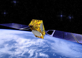
The satellites are using a new bus that features a phased array antenna for navigation signals and a laser retroreflector, with a launch mass 1,014 kg. Spacecraft dimensions are noted to be 2.25 by 1.0 by 1.22 meters. Usually, the satellites reside in a 21,500 – 21,400 km nominal orbit at 55.5 degrees.
The Beidou Phase III system includes the migration of its civil Beidou 1 or B1 signal from 1561.098 MHz to a frequency centered at 1575.42 MHz – the same as the GPS L1 and Galileo E1 civil signals – and its transformation from a quadrature phase shift keying (QPSK) modulation to a multiplexed binary offset carrier (MBOC) modulation similar to the future GPS L1C and Galileo’s E1.
The Phase II B1 open service signal uses QPSK modulation with 4.092 megahertz bandwidth centered at 1561.098 MHz.
The current Beidou constellation spacecraft are transmitting open and authorized signals at B2 (1207.14 MHz) and an authorized service at B3 (1268.52 MHz).
Real-time, stand-alone Beidou horizontal positioning accuracy was classed as better than 6 meters (95 percent) and with a vertical accuracy better than 10 meters (95 percent).
The Compass Navigation Satellite System (CNSS) is China’s satellite navigation system, approved by the Chinese government in 2004, capable of providing continuous, real-time passive 3D geo-spatial positioning and speed measurement.
The Chinese navigation system is being developed and deployed in three phases. Phase 1 (starting in 2003), consisted of an experimental regional navigation system, BeiDou-1, which provided active navigation service.
Phase 2 (started in 2012), consisted of a reduced satellite constellation and provides open service over China. This phase aimed at deploying a system with passive positioning and timing capability over a regional area.
Phase 3 aims for full operational capability by 2020 with a constellation of 27 MEOs plus 5 GEOs and the existing 3 IGSOs satellites of the regional system. CNSS would provide global navigation services, similarly to the GPS, GLONASS or Galileo systems.
CNSS is expected to support two different kinds of general services: RDSS and RNSS. In the Radio Determination Satellite Service (RDSS), the user position is computed by a ground station using the round trip time of signals exchanged via GEO satellite. The RDSS long-term feature further includes short message communication (guaranteeing backward compatibility with Beidou-1), large volume message communication, information connection, and extended coverage.
The Radio Navigation Satellite Service (RNSS) is very similar to that provided by GPS and Galileo and is designed to achieve similar performances.
The long-term goal is to develop a global navigation satellite network similar to the GPS and GLONASS by 2020 eventually consisting a constellation of 35 vehicles, including 27 MEO (21,500 km orbits) satellites, three IGSO satellites (inclined at 55 degrees) and five GSO satellites.
The system will be dual-use, based on a civilian service that will provide an accuracy of 10 meters in the user position, 0.2 m/s on the user velocity and 50 nanoseconds in time accuracy; and the military and authorized user’s service, providing higher accuracies. The first phase of the project will involve coverage of the Chinese territory. However, the future Compass constellation will cover the entire globe.
This mission is also the second flight of the Long March-3B/YZ-1 (Chang Zheng-3B/YZ-1) version of the Long March-3B. The launcher was developed from the Chang Zheng-3A.


The Beidou Phase III system includes the migration of its civil Beidou 1 or B1 signal from 1561.098 MHz to a frequency centered at 1575.42 MHz – the same as the GPS L1 and Galileo E1 civil signals – and its transformation from a quadrature phase shift keying (QPSK) modulation to a multiplexed binary offset carrier (MBOC) modulation similar to the future GPS L1C and Galileo’s E1.
The Phase II B1 open service signal uses QPSK modulation with 4.092 megahertz bandwidth centered at 1561.098 MHz.
The current Beidou constellation spacecraft are transmitting open and authorized signals at B2 (1207.14 MHz) and an authorized service at B3 (1268.52 MHz).
Real-time, stand-alone Beidou horizontal positioning accuracy was classed as better than 6 meters (95 percent) and with a vertical accuracy better than 10 meters (95 percent).
The Chinese navigation system is being developed and deployed in three phases. Phase 1 (starting in 2003), consisted of an experimental regional navigation system, BeiDou-1, which provided active navigation service.
Phase 2 (started in 2012), consisted of a reduced satellite constellation and provides open service over China. This phase aimed at deploying a system with passive positioning and timing capability over a regional area.
Phase 3 aims for full operational capability by 2020 with a constellation of 27 MEOs plus 5 GEOs and the existing 3 IGSOs satellites of the regional system. CNSS would provide global navigation services, similarly to the GPS, GLONASS or Galileo systems.
CNSS is expected to support two different kinds of general services: RDSS and RNSS. In the Radio Determination Satellite Service (RDSS), the user position is computed by a ground station using the round trip time of signals exchanged via GEO satellite. The RDSS long-term feature further includes short message communication (guaranteeing backward compatibility with Beidou-1), large volume message communication, information connection, and extended coverage.
The long-term goal is to develop a global navigation satellite network similar to the GPS and GLONASS by 2020 eventually consisting a constellation of 35 vehicles, including 27 MEO (21,500 km orbits) satellites, three IGSO satellites (inclined at 55 degrees) and five GSO satellites.
The system will be dual-use, based on a civilian service that will provide an accuracy of 10 meters in the user position, 0.2 m/s on the user velocity and 50 nanoseconds in time accuracy; and the military and authorized user’s service, providing higher accuracies. The first phase of the project will involve coverage of the Chinese territory. However, the future Compass constellation will cover the entire globe.
This mission is also the second flight of the Long March-3B/YZ-1 (Chang Zheng-3B/YZ-1) version of the Long March-3B. The launcher was developed from the Chang Zheng-3A.
No comments:
Post a Comment